GOBEKLITEPE. It is located in the Fertile Crescent -
also referred to as the Cradle of Civilization. Such a place aroused my
curiosity and regret not to have visited earlier; the word Gobekli means
“Potbelly Hill.” Now it is covered under
a giant umbrella and you are not able to walk and touch the ancient monuments;
now this is common among most ancient archeological sites. I remember back in the 1970’s, before global
tourism increased, walking among the ruins in Mesoamerica such as Tikal,
Palenque, Machu Picchu and others without restraints and the absence of guards. The good old days.


The site follows a geometric pattern due to the similarities
between the various enclosures. Eventually the site was abandoned and the
enclosures buried with animal and human bones allowing for the identifications
of what constituted the main sources of food such as wild grains and fauna such
as pigs, deer and various species of birds.

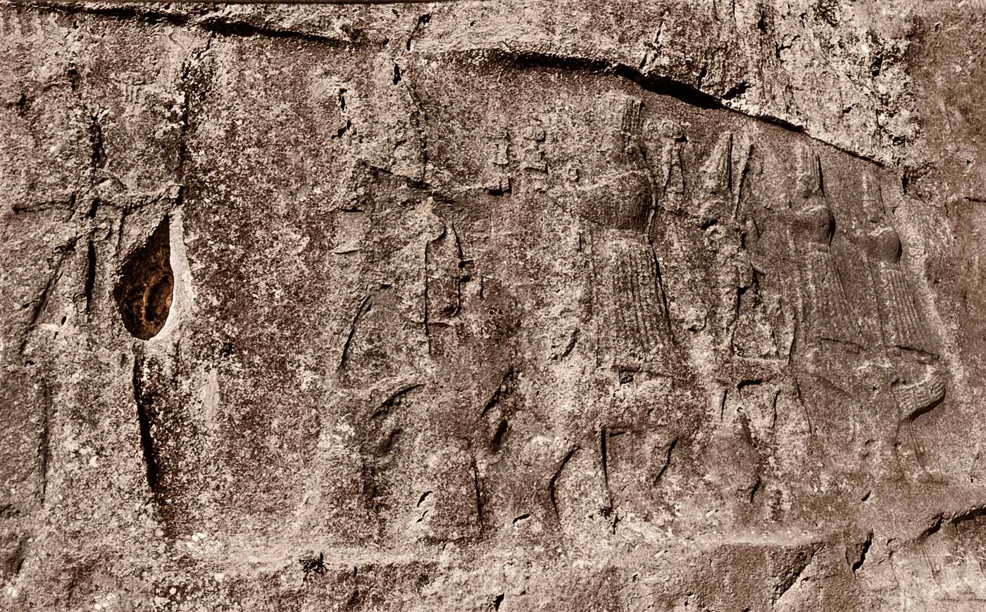
Peculiar about the site are the T-shaped pillars weighting
40-60 tons carved with images of spiders, frogs, scorpions, pigs, vultures and
others left to the interpretation of the observers. The second image below in black and white and
to the right, better illustrates what some have identified as a lion and a pig.
Most of the figures depicted are male and were sculptured with flint stones. It
is said that the pillars represent shamans.


ESKI HALFETI. Below is a view of the Euphrates River
where tour boats take visitors to the sunken village of Eski Savasan, which appears
to be a popular destination from the numbers of tourists eagerly waiting to go. It is a fishing village of Roman origins from
where the tours depart (to the left of the image below) and known as the home
of the famous black roses. These are
actually dark red roses but turn black as summer arrives. The lake seen was
created when the Euphrates was dammed at Birecik in the 1990’s resulting in the
submergence of various villages. Halfeti
was partially submerged and villagers were resettled to a new town about 15
miles away.


The legendary King’s Daughter’s Cave but not known what the
name is a 3 floors structure with 5 different caves and the one of the biggest
carved into the limestone walls in the area.

Rumkale means Roman Castle and is located on a peninsula
formed in the River. It said that Apostle Saint John lived here during Roman
times and reproduced copies of the Bible; this Apostle really moved around.
During its long history it was occupied by the Byzantines, Armenians and
Mamluks. It was also the site of the Barsavma Monastery built in the 13th century.
The castle is massive as seen from the two images below and the window
structures seen appear to be of most recent construction.


Across the small bay from the ghost town there is a
restaurant and an area to explore while my bodyguards enjoy a morning tea with
local figs and cookies. I wondered
around and found a partially inhabited cave house carved from the
limestone. This type of housing is
widespread along the shores of the Euphrates in the area and similar ones can
be found north of Granada in Spain. In addition several underground churches
are found in the area.

HARRAN. Or
Hellenopolis in Greek times when it fell to Alexander the Great goes farther
back in history from 3000-2000 BCE to early Bronze Age and Assyrian times. It
is mentioned in the Book of Genesis. The
battle of Carrahe in 53 BCE took place here known as Harran then, where one of
the Rome’s greatest defeats took place by the Persians. Emperor Caracalla mentioned in the previous blog
was murdered here in 217 AD. Another great battle was fought nearby in 1104
during the crusades. Located along the
road from Damascus to Nineveh (once the capital of the Assyrian empire) it was
a strategic location, not a good thing. Now it is known for its beehive adobe
houses that remain unchanged for more than 3000 years due to the ventilation hole
in the roof allowing hot air to escape while fresh air enters at the base thru
windows and doors. Now a historical site it invaded by hordes of tourists
searching for souvenirs and an opportunity to peek inside the structures…no
bees but plenty of flies.


Below are inside views where one can see that most of the
cones are interconnected and also a view of the beehive structure built with
adobe bricks


HATTUSA.
Former capital of the Hittite Kingdom a major power along with the Assyrians,
Egyptians, and Babylonians during the late Bronze Age. The origin of the Hittites is not known but
was a group of Indo-Europeans that migrated into the Anatolia around 2000 BCE
coming from the land of Hatti. At its peak the kingdom extended from
Mediterranean to the Euphrates. They
developed the fastest chariots and were making iron tools that may have given
them a strategic advantage during the battle of Kadesh where they almost captured
the Pharaoh Ramses who was forced to abandon the battle. Hattusa disappeared along with the Hittite
Kingdom in XII century BC. Below is a photo of a portion of the citadel that
covered almost a square mile surrounded by walls about 4 miles long and it
estimated that at its peak about 50,000 people resided there. Below is the
Great Temple.

There were several gates to
the city and below 3 images of the Sphinx Gate with winged horse and a human
head; the other column appears to be a woman. Next is the carving (reproduction;
the real one is at the Museum in Ankara) at the King’s Gate followed by the
Lions’ Gate. It is obvious that I like
the Sphinx best by the number of photos.


Yerkapi Tunnel “The
Gate to the Ground” in Turkish was part
of the fortification in Hattusa and is 70 meters long, 12 other such tunnels
have been discovered but this is the best preserved and completed in the XIV
century BCE. Below is the entrance to the tunnel and next notice that it is
triangular in shape. Hittites did not know how to build arches and the tunnel
is still standing after 3000 years…it is inclined downhill from the city and I
walked it both ways and noticed no carvings in the stones.


YAZILIKAYA. Is
a sanctuary at Hattusa about one mile away from the city consisting of two
chambers with covered with stone carvings. Below is the entrance to the
sanctuary and next are the 12 Hittite deities of the underworld procession.


Next is a carving of King Tudhaliya IV (1237-1209 BCE) holding
the god of the mountains Shamurra in his right hand who is represented as a
pair of walking legs. The king’s sister
was Maathorneferure wife of Rameses II; all in the name of political
connections to keep the peace; nothing changes. Regardless, the battle of
Kadesh in 1274 BC took place between Ramesses II and the Hittites in Syria
ending in a peace treaty 13 years later with King Hattusili III (1367-1237 BC)
father of Tudhaliya IV. It is said that
the battle was finished when the world’s oldest peace treaty was signed.

Next a procession of the Hittite gods where Shamurra (third from the right) follows his mother (both standing in top of panthers) facing King Tudhaliya IV. The Hittites had about 77 deities; some were adopted from other cultures that they were in contact such Istar a Mesopotamian goddess of love, war, justice and sexuality.
HERACLEA.
At the mall fishing village dominated by a large restaurant, festivities were
been prepared for a prospective wedding .

Appears like there has been a last minute difference of
opinion as the prospective groom walks away from the flowerer Audi where the
maid sat immutable and the photographed wondered if he was going to get paid. A
tourist watched the altercation from the far right; no doubt an American from
the outfit he was wearing…but is carrying a purse…definitely European.

Meanwhile I moved away not wanting to be busted for taking
photos and went to the front of the restaurant where an altar was been set
up…and then…a phone call to the attendant--no wedding unless you make a
miracle.

I got late to Heraclea so did not get to see the main ruins
but after weeks of trampling around the rocks of past glories not much was missed.
A view of some of the wall towers below.

KARAKUS TUMULUS. It is a man-made mound about 100 feet
high on top of a hill and the name means black bird for the bird (really an
eagle) standing in top of a Doric column about 30 feet.


Walking around the tumulus next there 2 columns, one with a
decapitated animal sculpture. Here Greek stone writing mentioning that in the tumulus
the short-lived most beautiful woman Antiochis was buried. This monument was
most probably built during the Kingdom of Commagene by King Mithridates II (38-20
BCE) who we previously met in Arsemia. In the inscription, the Greek word
heirothension that means sacred site or royal mausoleums. This burial site was
constructed for the royal women.

The head below resembles a lion and it was probably in top
of the empty column seen above since it is nearby. There are only 9 columns
left of the original of many others that were stolen to build the Cenderi
Bridge discussed in Part I of this blog.

Next is a column topped by a relief of King Mithridates II holding
his sister’s hand; Laodice, who was a Queen in the Parthian Empire, and buried here.
An underground chamber was discovered during archeological diggings by Germans
during the 1950-70s’. Nothing was found and is speculated that it was
vandalized at the time when the columns were recycled to build Cenderi Bridge. It is curious that this column remained untoppled
for more than two millennia.


MILETOS. Not
many tourists visit this site but it was one of the most important cities in
its time. It is originally Greek, who arrived in the X century; it was later
expanded by the Romans. A contemporary of Ephesus but not as extensive when
referring as to what have survived structurally except for the the Grand Theater
that was able to accommodate about 15,000.
Probably the most important structure now resides in the Pergamon
Museum in Berlin—the Market Gate. It was
built by Emperor Hadrian in 2nd century AD.

Miletos was the home to
various notables such as Tales, a philosopher and mathematician. His theorems
were able to determine the height of the pyramids, besides he said to have become
rich by predicting the weather. Others
were Hecataeus a historian and Hippodamus considered the originator of the grid
layout of cities. And probably we all
know of the Hagia Sophia in Istanbul; it was designed by Isidore of Miletus,
physician, mathematician and architect,

The city at the time it was
completed surrounded by water and next to the Meander river. For those who know geology a meandering river
is one that changes courses thru time; such name was derived from this
river. It is not longer closer to the
sea due to the sediments carried by the Meander River; a similar case in
Ephesus but caused by a different river. At one time the theater stood facing the
waterfront.


This is the second section of the Turkish adventure…it took about a month to visit the various sites and a year later, I finally got to almost finish writing the blog...as promised Part 3 will be finished by the end September.


2 comments:
It is amazing that these buildings are still standing in places, I guess due to the dry climate. Bodyguards?
No bodyguards seen anywhere in Turkey other than the airports.
Post a Comment