MIDAS MOUND. A 2700 year old burial tomb in Gordion,
the ancient capital of the Phrygian Kingdom.
It dates from the middle period (ca 730 BCE) and is the second largest
in Anatolia. King Gordias tied a knot (Gordian knot) to the yoke of his wagon
and the myth goes that whoever could untie it, would become the ruler of Asia. Along came Alexander the Great (336-323 BCE) who defeated the Phrygians and
undid the knot with a single stroke of his sword. Another version is that he just
pulled out the peg holding the end of the knot.
Excavated in the 1950’s the archeologists found bronze
artifacts, iron drinking cups, pottery, furniture and textiles. It is not
confirmed that Midas was buried there but probably his father Gordias. Midas in mythology was the one converted into
gold anything he touched into gold; so he had the “golden touch.” All myths
have a related basis and it happens that the river Pactolus was rich in gold
deposits and it was used in Gordian coinage.
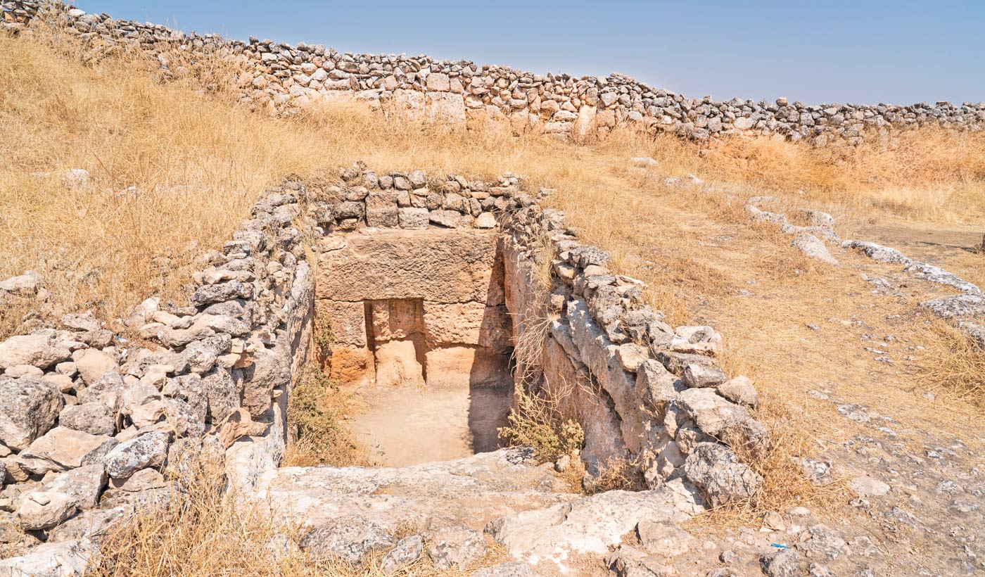
Past the green gate (above) there is a long tunnel that
leads into the burial chamber. Once inside there is not much to be seen but the
tomb made of large timbers held in place by
steel retainers. From the timber
dating it was determined that they were cut around 740 BC. The original funeral
burial with the artifacts can be seen at the Museum of Anatolian Civilization
in Ankara.
Just crossing the road from the entrance to the tumulus is
the Gordion Museum where the oldest world’s mosaic is preserved; notice the geometric
patterns are not depicting landscapes or people. Next a carved stone marking an historical
event or a Roman Tombstone with a figure of an angel.


Gordion was the capital of
the Phrygian Empire between 750-600 BC and built upon the ruins of a Hittite
city. The Phrygians were an early Iron
Age civilization who controlled most of western Anatolia during the 9th
to 8th centuries B.C. The
river Sangarios (Sakarya) sediments buried parts of the ancient walled city but
were excavated and some of the major remains can be seen below. With the
arrival of Alexander, the city passed thru a Hellenistic, Roman, Byzantine,
Ottoman periods to present Turkey.
Battles during the Turkish War of Liberation (1921) took place in the
area where remnants can still be found.
Images of the citadel are below and in the first one in the center of
the horizon Midas Mound is visible.


MOUNT NEMRUT. A
place I always wanted see and finally got there; just like in Gobeklitepe 20 years late. It is the burial site of Antiochus I
King of Commagene (69-36 BCE) and son of King Mithridates - I previously
mentioned him in this saga. He built this extraordinary monument on top of a 50
meter high tumulus on top of the Mount…imagine the manpower required to bring
all the materials up just by looking at the tourist trail below leading to the
top.


One reaches the West Terrace
first where one is greeted by the head of King Antiochus – just behind the head
of the eagle. The images below show a better perspective; one in color and the other in black and white. This site is an extreme challenge
for photography because of its location, number of tourists and accessibility.
It is composed of a West side - the most accessible because it will be an
afternoon climb and a spectacular sunset view- and an East side is the sunrise and to get there one
must start an early morning low temperature climb about 3 AM and will have to
make special arrangements with the Park Guides to lead you there people. I gave
up the intention of doing the morning climb and photographed the East Terrace
in the PM.
Still on the West terrace, heads
from the right are Zeus, Apollo (center), and the goddess Commagene at the left.
Notice that both the East and West terraces depict slightly different versions
of the same deities.
I found the East Terrace the
most spectacular where a row of thrones with decapitated seated royals is seen;
notice the heads at the foot of the mound…not to mention the tourists. The
thrones from left to right represents those of Antiochus I Theos, the King of
the Commagene, Goddess Commagene, Zeus, Apollo and Heracles…note that these
statues were given different names through history. At the end of the row of
thrones there were a lion and an eagle guarding the site.
Next is a public domain photo
from a 1890’s German expedition showing that the head of Commagene still in
place. Notice the man standing next to the head of Heracles in the left lower
corner. Archeological restorations can
also be seen of the thrones as well as a
wooden sidewalk to make the area easily accessible to the public (compare to
above image).
Below a photo of the row of
heads looking North. In the first image, the head next to the eagle is that of
King Heracles followed by those of Apollo, Zeus, goddess of Commagene and King Antiochus I
at the far end.
Next same as above but
looking in the opposite direction; notice that there is an eagle head at this
end too.
Returning to the West Terrace,
tourists congregated to watch the sunset
while a wedding party made a video and another visitor dreams of having been a Commagene
princess in her previous life. This a site that if I had a bucket list it would
have been #1.
PIERNE. This
Ionian city located near where the Meander River enters the Aegean Sea is
located on of Mykale Mountain and requires a
stiff trail climb to reach it. It is near Miletus and founded by the Hittites
but not at its present location that was buried by sediments carried by the
Meander River. Greeks arrived around 1000 BC and it was rebuilt by Alexander
the Great as a planned city. Below are
the remnants of the stage and to the left several doors that of rooms where the
actors prepared for the shows.
The theater has preserved its Greek origins although it was
modified during Roman times and estimated that it could accommodate about 5000
people. Notice that some seats are decorated with Lion’s feet and reserved for
the eminent citizens of the time.
It is a best preserved of the old Greek cities and the
second most studied one after Pompeii and built of marble from the quarries in
Mykale. Built in two terraces and supplied water by an aqueduct from the nearby
mountains and distributed thru the city by clay tiles that still can be seen.
Below is the Temple of Athena’s built around 335 BCE paid for by funds provided
by Alexander the Great and classified as in the Ionic style. The columns were
reassembled in the 1960’s but one of the sections was forgotten so they stand
shorter than originally constructed.
And the next image is that of the Bouleuterion equivalent to
a Senate Chamber or City Council Hall in current times and in the background is
the cliff side of the acropolis.
SANLIURFA. The original name was Urfa but in 1984 changed to the
present name by adding “sanli” meaning glorious because of its role in the
Turkish War of Indenpence. It is one of the oldest cities (back to 9000 BC) in
the Crescent of Civilization at the crossroads between Mesopotamia and Anatolia.
Starting at the Hazreti Ibrahim Halillah, the cave where legend claims that
Prophet Ibraham Halilullah was born in secret from King Nimrod is below. The
king was warned of a new leader to be born so he ordered to kill all the newborns…this
story sounds familiar. . It is said that
the water is among the healthiest but I would not drink it.

Nearby are the Sacred Fish
Ponds (Balikligol) formed when King Nimrod burned Prophet Ibraham for preaching
about a monotheistic religion. God
intervened and a storm lifted Ibraham in the air and where he landed the fire
turned into water and the embers into fish. Believers feed these holy carps but
if they are killed, the perpetrator will go blind…didn’t see any blind people.
Above and below is the Rizvaniye Vakfi Mosque and Madrassa
an important place where pilgrims gather on their hajj to Mecca.
The area around this complex is full of people just having a
great time, some just watching tourists going back and giving killing stares.
But needless to say during all the time in Turkey never had an unfriendly
episode; on the contrary everyone was welcoming.
Around the ponds are small shops mostly selling textiles and
food. Below where the building with the Turkish flag is hanging, and to the
left, where people are congregated, assortments of colorful scarfs were waiting
to be purchased.
The Mevlid-I Halil Mosque is the oldest of the Mosques in
Urfa (short for Sanliurfa); it originated as a pagan temple, a synagogue, then
transformed into St. Stephon Church during the Byzantine period (150 AD) and
finally into a mosque built in 1523. The
cave of Ibraham is next to it and Mevlid means “Holy birth.”
Below to the left is the Wudu (washing place) with two
minarets in the background and Urfa Castle is where the Turkish flag is flying.
Walking down the streets towards the bazaar where lots of
people conducting their daily business crowd the street. One cart pusher is
selling cantaloupes while another is bagging what looks like colorful
mushrooms.
The Firfirli Mosque also known as the "new frilled
mosque" because of its gothic style decoration was formerly the Armenian Church
of the Twelve Apostles. By the end of
the first World War Armenians were thrown out and the church turned into a
prison and later converted into a mosque in 1956.
The Sanliurfa Museum was inaugurated in 1969 and is a
magnificent architectural building and the warden of unique archeological
treasures. Its geographic location in a rich historical area gives it
advantages as a leader of archeological excavations providing with an extensive
collection of artifacts from antiquities.
The Haleplibahce Mosaic Museum also here stores the largest
collections of mosaics in the world; these can be seen from above from the
elevated passageways seen in the image below. Mosaics were made from mostly
square cut stones from the Euphrates River. Some of the mosaics depict the earliest
representation of the Amazon warrior women (first below) followed a wounded
lion and then carpet with a copy of a mosaic that can be seen hanging from the
wall in the photo above.
The Urfa Man is the oldest man-size statue that has been
found and is 6 feet tall and the eye sockets are filled with square pieces of
quartz. Found in Balikligol near Urfa and dated back to 9000 BC and contemporary
with Gobeklitepe. Another stone statue that attracted my attention since it
resembles the totem poles of the Northwest Coast USA Indians.
The museum holds reproductions of the monoliths from
Gobeklitepe and original artifacts.
Carvings in the stones are easier to see here than at the original site.
Below is one of a pair of cranes near water (represented by the zigzag lines).
One appears holding a stick standing in top of the other suggesting that they mated
and are building a nest.
Han-EL Barur Caravanserai is near Sanliurfa and dates back
to the Asyyubids Christians (circa 1219 BCE); the word barur means goat manure
in Arabic. The story goes that the owner
supplied the caravanserais with accommodations and dried grapes and used to say
“after me people would fill this place with goat manure.”
The underground dwellings were large and allowed for inhabitants to
stand erect. Some are still in use but mostly as animal enclosures or storage.
Shelving was built into the walls and inscriptions were carved on the
walls. I traced one of the walls graffiti depicting goats but the
others may be just plain writing or celestial monsters. Most walls have similar
decorations.
SIRINCE. An old orthodox village in the top of a
mountain preserves the typical Greek house of the pre-Turkish War of
Independence of the 1920’s. It is really
the epitome of a tourist town with not much to offer in the way of ancient
archeology. A small place of about 600 locals that I bet get overwhelmed by the
daily influx of tourists exponentially.
What it has to offer is a refuge of the daily drives and
timetables and sit down and relax, eat from a variety of fresh fruits and have
ice cream melting before you can eat it…it gets hot in the summer. It is also
famous for its wines. Besides tourism it also produces honey, olive oil and
wines…did not see any cheese.
The main streets are bordered by a continuous row of stalls
peddling souvenirs but mainly food and candies.
I bought just out of guilt, these sellers reminding me of spiders that patiently
for a fly in the web. In this case the flies are two-legged.
The village was originally settled by liberated Greek slaves
and suffered during the period of population exchanges between Greece and
Turkey. As a result it reached a state
of abandonment that was reversed in
the early 1990’s when homes began to be renovated into B&B’s, small hotels
and restaurants. These were expecting an economic surge in 2012 when the Mayan
Apocalypse was to take place, since the village was considered a “Doomsday Safe
Heaven because it has “positive energy” and about 60,000 cultists were
expected. But only a few showed up.
SOGMATAR. Two carved figures are located in the
Sacred Hill, the bust of a woman (Moon Goddess) at the left and a full bodied
man in the center. In top of the man’s head is scallop shell symbolizing the
sun god Shamesh. There is an underground temple with reliefs of human figures
and stars. It is estimated at one time
the hill served as an astronomical site and of planetary worship. Sogmatar is
derived from the word matar meaning rain.
A Syriac writing on top of the hill dates the statues to 476
in the Seleucid calendar (164-165 AD) there are several translations and one is
below is one.
“I am Tridates, the
son of Arab Governor Adona. I built this altar and pillar for Marelahe on
February in 476, for the lives of my master King and his sons, for my father
Adonna's life, for my own life and for the lives of my siblings and my
children.”
Nearby was a school closed at the time but the caretaker
allowed us in to use the loo. Very nice and clean - a recent construction since
I read in another blog from the early 2010’s as to the poverty of the area and
the dilapidated state of the school. The
area is still poor but the children look happy - entertaining themselves with watching
the tourists but well behaved…did not ask for baksheesh.


STRATONIKEA. This
site went thru variations in the spelling of its name and once named
Hadrianopolis…yes, in honor of Roman Emperor Hadrian…the one that built the
wall in England to keep the savages out.
It is dated back to prior to 260 BC during Seleucid times and named after
the wife of King Antiochus II Theos. It reminded me of Aphrodisias where I visited
more than 20 years ago when still people lived among the ruins. It is still the case here but appears that encroachers
are abandoning the archeological site or pushed out. Below are examples of what
I am talking about. Second image below
shows how an ancient marble entrance was recycled into a gate.
Next two photos further document the present of modern
structures among the ruins and the third one show marble stones stored probably
for further site reconstructions…what a jigsaw puzzle to put together.
The Roman period brought prosperity to the town as shown by
the theater that could accommodate around 10,000 spectators. The rows of seats
as can be seen below collapsed during an earthquake but otherwise is good state
of preservation.
Below are images of the Gymnasium dating back to 200 BC,
notice the circular wall in the rear and the roofs of contemporary homes; these
are currently occupied. It is the largest
one from the Ancient Period perhaps due that at one time was a center of
gladiators training and retirement if they lived that long.
Below is one of the walls of the Agora or interpreted by
others as the Bouleuterion that are still standing massive marble blocks. Here ends the longest blog that I have uploaded. Lessons learned from this trip is that one must research the places to be visited before one arrives there. My failure to to so caused me to miss photos of major items of interest in many of the sites visited.
Finally, you may find that images may show the best quality and the reason is that I had seen some been uplifted from the blogs and been sold by others. Also some of the photos are in Black & White to introduce more contrast and detail.