This was my
third cross country trip with a journey covering 6,000 miles crossing 13 states
from Virginia to California. The major goal was to go to National Parks along
those states next to the Canadian border to include North Dakota, completing my
goal of visiting all the states in the USA, and then going southwest from
Idaho. Started in Virginia and ending in Fresno, California. Traveled almost non-stop
the first 24 hours, just stopping for meals and gas until arriving at Bismarck,
N.D. The route took us mostly via I-64, 95, 270, 70, 76, 80, 94, to Billings,
Montana. From there State Routes 72, 120
and 20 to Yellowstone. Passed Yellowstone to Craters of the Moon via Rts 20,
Rt. 33 and into I-84 to Boise that was used as a base to explore the Snake
River Basin. Then back-tracked via I-84 to Twin Falls heading south on Rt.93 in
Nevada to Ely where junctioned Rt. 6 heading to Death Valley. From Death Valley headed to Bakersfield via
I-40 and then south in I-5 to Rts 106 and 101 ending in Solvang; actually the official
end of the trip where I visited a fellow adventurer. From there drove via Rts.101, 46 and 41 to
Fresno from to fly home.

The
Belvidere Oasis in the Illinois Tollway has been redone since the last time I
was there when it was all run-down and dirty. It is built as on a bridge over
the Interstate. Stopped here at McD for a Mocha Frappe @ 2 AM on 6/17/17.
Encountered severe weather several times mostly crossing Wisconsin and
Minnesota.
One of the
rewards of travel is encountering history that I was not aware of such as the
trails described in the image below.
These trails were used between 1820 and 1870’s connecting Canada to the Mississippi
River and connected the Red River Colony to the world. The colony had a complicated
history with no time to elaborate on it here. But the Trails were influential
in the development of the central states bordering Canada. Leaving this site
behind, arrived in Fargo, N. Dakota; a city made famous by the movie of the
same name. The mental image I had of the
city because of the movie did not match its actual looks.
The first stop was at Bismarck to visit a friend met
during the Missouri River Lewis and Clark trek of 2013. Always been intrigued
with this area because of its association with the Lewis and Clark Trail expedition
that wintered nearby during 1804-05 with the Mandan Indians. I visited the Lewis
and Clark Interpretative Center in Washburn that focuses on the history of the
winter that they spent in the area. The
monument is located at the entrance of the museum which is rich in artifacts
and houses a complete collection of Carl Bodmer’s prints. Carl Bodmer was the
Swiss illustrator who accompanied the expedition of the German Prince
Maximilian Expedition of 1833 up the Missouri River for about 2,500 miles by
steam and keelboats. Below is a Bodmer work depicting Maximillian in green coat
at Fort Clark followed by a model of the housing used by the Mandan Indians.
Nearby is
Fort Mandan, a replica of the winter quarters of the Lewis and Clark Expedition. They wintered here during 1804-1805 and where
Sakakawea first met with Clark and who was instrumental in the successful
completion of the expedition.
Spent two
nights in Dickinson, N. Dakota from where I visited the Theodore Roosevelt
National Park. Theodore came originally to this area to hunt bison and fell in
love with it and eventually started the Elkhorn Ranch. The park is part of the
Badlands with interesting geological formations among them, the Cannonball
Concretions below that I found most interesting.
Painted
Canyon is photographically challenging due the numerous color and erosional patterns
making it difficult to select what to photograph, not just due to the diversity
but also to the changing illumination during the day. Notice the wooden snake.
When it
comes to wildlife one runs into a few itinerant humans but bison and wild horses
are the most predominant. Are the horses wild or just feral? I propose that they are feral since they are
really escaped and are descendants from those brought to America by the Spanish
Conquistadores. The horses radically changed the plains Indians way of life and
without them the western culture would have not happened and Custer may have
not been killed at the Little Big Horn. Now the horses are “managed” as are the
bison; anything wild left? Time to depart leaving the flowers behind.
Below is
Theodore’s Maltese Cross Cabin where he first arrived in the area to hunt
buffalo; this cabin has been moved several times for exhibitions at places as
the St. Louis World’s Fair and the Lewis and Clark Centennial Exposition of
1905 in Portland Oregon, in 1910 to West Fargo and then to the State Capitol
till 1959 before moved to its present site in the southern part of the
park. He used it only between 1883 and 84.
Driving West
in I-94 saw a sign for Pompey’s Pillar National Monument which I never heard
about or rather did not recollect. Just out of curiosity decided to stop…what a
reward. It turned out that it is a 150
feet tall rock formation visited by William Clark in 1806 who inscribed his
name on it. He may or may have not the first to deface the rock with his
signature. The rock is protected now so
additional carvings are difficult; but I scented it instead. The pillar was named by Clark for Sacagawea’s
son who he named “Pompy” whose real name was Jean Baptiste Charbonneau, whose
father was a French-Canadian explorer and member of the Lewis and Clark
Expedition. There is a visitor’s center
that was built in 2006 again covering the Lewis and Clark Expedition with
various exhibits and collections of artifacts.


Continuing
West the next overnight stay was at Cody, Wyoming. The panorama below was taken in the Bureau of
Lands just north of the city. What a spectacular
view; went there looking for horses at sunset but none were seen. Next morning
entered Yellowstone overcrowded by tourists; lucky to find a room in Cooke
City, and old stomping ground visited several times in the winter trying to photograph
wolves. Second image is the creek feeding Trout Lake where I went
looking for river otters but none seen. The flowers are from around the
lakeshore. During previous trip I was very successful photographing them
fishing. My lifetime biggest photo equipment loss occurred at the parking lot when
the tripod failed and the lens and camera were damaged beyond use for the rest
of the trip; fortunately I always carry back-ups. The gear was repaired but not to their
original performance…Thank You Canon.


The typical
fauna was seen such as the goats, pronghorns and bears but in this occasion had
the opportunity to observe a red fox hunting ground squirrels. It was easy pickings for the fox; some of the
squirrels just froze when they saw the fox and did not run away. In about 10 minutes it captured 5 squirrels, swallowed
them whole and then took a mid-day siesta.


Bison as always
were everywhere but I observed that in Mammoth Hot Springs they wander around
the staff housing and are using the yard irrigation system to take showers and take
turns moving on when finished. In the
Lamar Valley the tourist wolf watchers were anxiously looking for the elusive
predators that are mostly seen as small spots moving across the valley even
with powerful scopes. I have gotten to know some of the professional wolf
spotters who are perennial fixtures and are incredibly knowledgeable; they know
the wolves in such detail that they could create the ancestry.com of their
families without the need for DNA samples.
Craters of
the Moon in Idaho was another photogenic jewel not well known and worth a more
extended visit. I was lucky to be there
at the peak of the flower blooming period, protruding from the dark granular
lava sands. There is some volcanic activity as shown below by the image of a
tufa pipe opening.
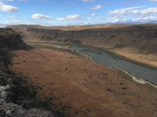
Stayed in Boise to visit the Snake River Basin; had no
idea of the vastness of the river and the majestic landscapes as well as the
history. What originally took me there
was to photograph the large migration of raptors found in the area. But the river basin was most attractive. Below there is a panoramic photo (created
from the merging of the 3 following images) to show the expanse of the area. For
more details go to https://idfg.idaho.gov/ifwis/ibt/site.aspx?id=65.
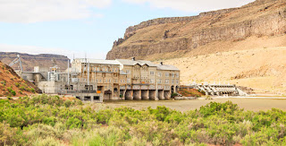
The Swan
Falls Hydroelectric Dam was built in built in 1910 to provide electricity to
nearby mines and modernized 80 years later.
Along with other dams they impede the total migration of the anadromous
fish up the river. There is a recreational area with weird signs prohibiting
the burn of pallets? Still scratching my
head of why?
Another
interesting structure nearby is the Guffey Bridge; details are below. Traveling along the farm roads several cattle
were seen with huge piles of manure as well as agricultural farms using large
irrigation systems. As from the farmer’s
homes seen, these must be the richest farmers I had seen in my travels around
the country based in the size of the homes and the numbers of mobiles homes
parked alongside. Based on the size of the RV’s, I guess that during the winter
they close the farms and become snow birds. Torrential storms accompanied by
hail were a daily occurrence when cruising around this area.


Next stop
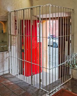
was Ely, Nevada, where the Ramada Inn was the overnight oasis. A very peculiar one since all the rooms
opened to the inside court where the Copper Queen Casino is located. You could hear the clicking of the coin
machines and the expressions of joy when a gambler hit the jackpot inside the
room. Interesting all the noise was gone
by 10 PM; most gamblers must have been drunk by then. Ely was an important railroad town and where
the Nevada Northern Railway Museum is located with hosts dressed in the proper style.
Nearby are the Ward Charcoal Ovens used during 1876-79 and built by Italian
carbonari. The charcoal was used for smelting silver at the Ward silver mine. Last
year I was in southern France and the stonework is very similar at that used in
medieval cone shaped homes in the towns of that area; see the third image below.


Entering
Death Valley under record high temperatures with warning signs along the roads…Why
would they want one to stop to enjoy such heat?
Photographed there late on the day and early in the morning to get the
cooler temperatures and best light. I had not been here in more than 30 years
and noticed not much change other than more park buildings, people and restrictions;
a sign of the times all over the world. Notice the “NO” drone sign.


Next was
just a straight drive to Solvang to visit my friend Richard, a companion of many
adventures around the world. Visited here about 30 years ago and has grown becoming
a tourist trap; what is called progress. Danes established a colony here in
1911 and while there during my previous visit the bakers could be heard
speaking in Danish but that parlance is now gone but the tasty pastries remain.
The Spanish mission of Santa Ines built in 1804 looks the same but for the huge
parking lot in front of it. This was the last stop of the trip from where I
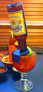
drove to Fresno to fly home. Had a lunch there at a Mexican restaurant and saw
a different Michelada; go and figure how to drink the bottle of beer.
Took sometime
time to put this long blog together due to the number of photos taken and busy
gone most of the summer. Will try to catch up with the other places visited
before the end of the year but don’t hold your breath.
About the
images, these were processed some as regular, HDRs, and posterized and taken
with a digital full frame camera or iPhones. Also the quality is not the best because
some of my images have been stolen and sold unauthorized.


